Trolling for More and Bigger Crappies, Part 1
Bob McNally 04.21.16

It’s crappie catching time throughout much of America, and anglers are working many of the nation’s better waters catching plenty of good-eating “slabs.”
Trolling and controlled drifting is the main game for many fishermen, simply because it allows a lot of water to be covered in the shortest amount of time. A good variety of lures and baits also can be employed different ways at the same time to learn which are most productive.
But if your trolling simply consists of tossing out a couple jigs with spinners attached or soaking minnows while plowing water with your boat, you’re not tapping the full potential of trolling. Put another way, you’re not catching as many fish as you could be.
From the outset, understand that trolling without using a sensitive fathometer with GPS mapping is folly. You’ve got to know what’s under the boat if you’re going to consistently catch crappies (other fish, too).
Knowing, for example, that a submerged point of land slowly tapers from 6 to 8 feet, then drops sharply at 10 feet to 15 gives an angler well-defined “edges” to make effective trolling runs so his lures and baits are “in the fish zone” for the longest time possible.
An accurate fathometer shows sunken weed beds, rises in a deep structure signifying a “hump,” reveals stump flats and standing deep timber, channel edges, even fish and bait. Frankly, without a fathometer, you are literally trolling blind. So if you catch fish you’ll probably not be able to repeat the identical trolling pass, and you aren’t likely to catch additional fish quickly from a school.
This is where GPS, waypoint navigation, and navigational mapping is an important aid to catch crappies every time out. And such electronics are not that expensive, at least in the grand scheme of fishing costs. For a few hundred dollars, a good depth finder unit by Humminbird, Lowrance, Garmin, or others is some of the best money an angler can spend.
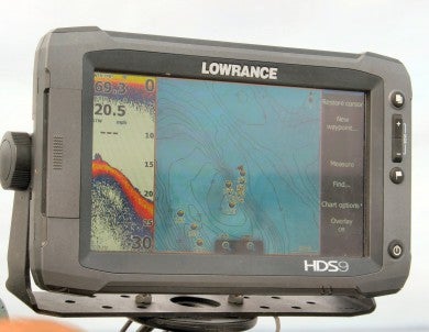
Most such units have a charting feature with a huge memory base that allows anglers to record their exact trolling passes, and when fish are contacted, a waypoint can be assigned quickly to the spot. Such track charting with waypoints for fish are overlaid on a bottom contour of the water trolled. Detailed hydrographic maps of almost all named lakes, rivers, and inshore waters are available and are easily loaded into depth finders with GPS.
Detailed maps of crappie trolling areas with waypoints where fish are caught can be locked into a depth finder unit and used for reference any time an angler is fishing.
In a very short time patterns emerge about where fish are found and caught trolling. You have a detailed map of when fish are present, precisely pinpointed caught-fish spots, time of year, water temperature, etc. It’s modern angling at its best, and it can be deadly for winter crappie trolling.
