How to Read a Topographical Map
Kevin Felts 03.16.18

For the purest out there, and for people who would like to learn about TOPO maps, let’s take a few minutes and talk about how to read a Topographical (TOPO) map.
It seems map reading skills are becoming a lost art. Or maybe, it already is a lost skill? It is amazing how people feel with the innovation of smart phones and Google Earth, who needs map reading skills?
In fact, while watching YouTube videos about hiking and backpacking, TOPO maps are rarely mentioned. Even the most basic of land navigational skills are rarely talked about. Which is a shame.
Let’s get started.
What is a TOPO map? It is a map published by the United States Geological Survey.
A standard TOPO map should show rivers, creeks, bodies of water, roads, elevation, land contour, buildings, cemeteries. The typical stuff someone may expect to see on a map.
At the bottom of the map will be a scale and legend.
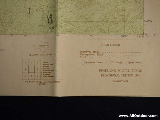
On the sides of the TOPO map should be latitude, longitude and Universal Transverse Mercator coordinate system (UTM). On a personal note, I use UTM when hiking.
Who uses TOPO maps? All kinds of people – hikers, backpackers, survey crews, foresters, pipeline crews, powerline crews, anyone who needs a detailed map.
Where can someone buy a TOPO map? They are available on the Internet. I buy mine from a blueprint company in Beaumont, Texas.
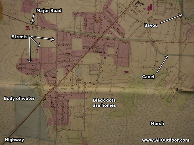
Looking at the TOPO map of Bridge City, Texas, we know the land is relativity flat. There are very few contour lines, no hill tops, and almost no creeks. Elevation is 10 feet, so we know this probably going to be a coastal plans area.
The body of water to the left is man made. We know this because the contour is to the community and the straight lines.
The marsh means there may be a river nearby.
With this being a coastal plans area, chances are the water is going to be brackish. Brackish water is a mix of seawater and freshwater. Simply put, the water in the marsh and bayou will not be safe to drink with a regular water filter.
In all honesty, I grew up in Bridge City, Texas. The marsh connects to the Sabine River and Sabine Lake. I know the water is brackish from first hand experience. The body of water to the left is a cooling pond for a power generation plant.
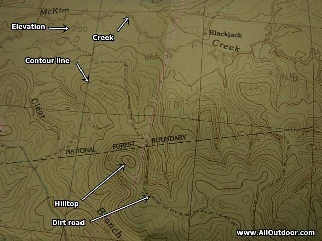
Looking at a TOPO map of the Sabine National forest near Pineland, Texas, we know a dirt road passes to the east side of a hilltop. We also know the boundary line of the national forest is just to the north of the hill.
Elevation is around 200-372 feet, which means these are rolling hills.
The jagged line depicting a road is a dirt road. The solid line is an improved road, probably a paved county road or farm road.
Using the map we know there is a good chance of water being in McKim and Blackjack creek. The low areas between the hills would also be a good place to look for water. Feeder creeks would start between the hills and then work their way to the larger creeks.
Final Thoughts
The best way to learn how to read a topographical map is to do it. Buy a map of your town. Then walk through the neighborhood while looking at the map. Go to a local park and use the map while walking through the park. This provides the opportunity to read a topographical map in a controlled setting.
In the coming weeks we are going to take the skills discussed in this series on land navigation and put them to use in a real world application. One place we may go is a river area discussed in this article about how to find a bearing using a TOPO map.
Be sure to check out all of our articles on land navigation.
Readers, share your thoughts and suggestions in the comments section below.
